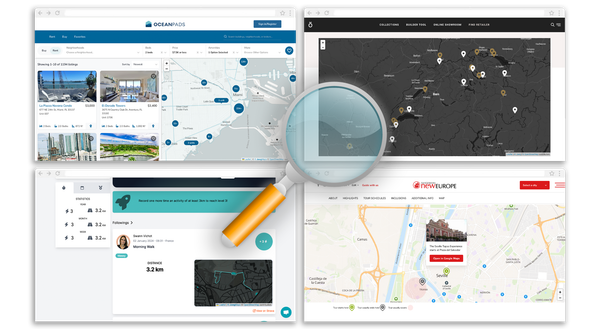
Parlons Tech Rétrospective 2020, une grande année pour la carto On fait un point et on revient sur 2020 pour comprendre comment cette année insolite a influencé le monde de la carto.
Nos Produits Embrace the new streets-v2 tileset Discover our new tileset: streets-v2 with better language management, better 3D building, vector tile size reduced with various improvements.
Nos Produits Maps in your language Discover the new features of Jawg Maps : automatic language, road shield, static maps custom icons and logo position.
Nos Produits Jawg x Pelias Geocoding is the second most used service at Jawg (after base maps). We added this service in January 2017 and we are happy to have chosen the Pelias project for our geocoder.
Nos Produits Earth's oceans and seas From space, we can see that the surface of our dear planet is mainly composed of water. Oceans and Seas covering a good part of our maps and we now display their names.
Team News Jawg visual identity through time We changed our visual identity after 3 years because it's very important for a brand. It helps to distinguish a brand from the crowd of other business.
en Elevation Service Use Case: Hiking Our Elevation Service provides elevation data above the sea level for any location on Earth’s surface. This is useful for hiking, biking or motorcycling applications. In this article we display a hike on a map and then plot a chart of its height.
Nos Produits Add relief to your maps Hillshade and contour: Two vector layers for relief visualisation.
Nos Produits Do you want some icons on your maps ? Icons are deeply linked to the maps we use every day. Universal symbols, they do not suffer from the language barrier and allow to be understood by all.
Nos Produits Introducing our new routing profile It's been a long time since we introduced our car routing service. Now, we are please to announce our new routing profile: walk. This profile is focused on pedestrian routing.
Nos Produits Rendu GPU @ jawg Cela fait quelques mois maintenant que nous avons sorti les hillshades et landcovers. Cependant les hillshades n'étaient disponibles uniquement sur vos styles vectoriels. Maintenant ils le sont également dans vos styles raster !
Nos Produits Jawg Maps is evolving every day Discover the new features of Jawg Maps : OSM data management, transport network, hillshades, landcover ...
Parlons Tech To build or not to build ? Faire ses maps soi-même, la meilleure alternative ? 16 Juillet, Google Maps change ses pricings... Pensez aux alternatives ! Quand créer son propre serveur de tuiles? A quel moment dois-je choisir un prestataire spécialisé ? On vous apporte quelques éléments de réponses.
Nos Produits Jawg Maps et la rencontre OpenStreetMap Pourquoi Jawg a choisi de collaborer avec OpenStreetMap, la vraie alternative au changement de pricing de Google Maps ? Car c'est une initiative collaborative et participative, qui choisit la transparence des données et l'opensource.
Parlons Tech Hillshades and Digital Elevation Model Our latest release of the Jawg Lab allows you to include the best shaded relief on your maps. Quick tutorial: Add hillshades to your style Go to the style manager.
Nos Produits Introducing Map taxonomy chart with Jawg Maps Sometimes, we want to see our map style outside the map context. That's why we created the map taxonomy chart project. Jawg taxonomy aims to view almost all your style
Team News Plaidoyer pour la Perf L'entrée dans l'ère du Cloud Computing et du DevOps a permis de nombreuses choses: fluidifier l'innovation, faciliter l'industrialisation du logiciel, diminuer les investissements et accélérer l'arrivée sur le marché (TTM)
Parlons Tech Docker Multi-Stage Build On June 13, 2017 took place the Paris Container Day. At the opening of the conferences they unveiled a new docker feature : multi-stage build. That's the subject of this article.
Parlons Tech How to make mvt with PostGIS Since PostGIS 2.4.0 it is possible to generate mvt (Mapbox Vector Tile) out of the box. In this tutorial we will create a minimalist set of vector tiles
Parlons Tech Nos images sont-elles sages ? Depuis fin 2016, plus d’une page internet sur deux est chargée depuis un mobile. Un changement de paradigme qui est loin d’être sans conséquence pour l’industrie. La
Nos Produits Metrics : comprendre comment vos usagers consomment vos maps ! "Metrics" : le premier dashboard analytics orienté maps ! Jawg vous propose d' en faire un assistant incontournable dans votre stratégie digitale orientée maps .
Team News Opération Caribe Wave: Geeks vs Tsunami C’est le constat criant de l’ONU : 90% des catastrophes naturelles enregistrées dans le monde depuis 20 ans ont été causées par les bouleversements climatiques. Pourtant, des investissements technologiques
Parlons Tech Succès = Immersion + Compréhension Qui parmi-vous a déjà râlé après son smartphone parce qu’un site se charge lentement? Allez, sans trop prendre de risques, on imagine que c’est le cas pour vous.
Team News Alerte MasterClass!!! Jean-Luc paye sa masterclass! Jean-Luc a découvert l'arrivée du web quand vous n'étiez même pas né. Comment le web est arrivé? C'est quoi Netscape? C++? JEE? Django? Rails? Angular? React.
Nos Produits Introduction à Jawg Lab L’équipe de Jawg est fière de vous annoncer le lancement officiel du Jawg Lab, notre plateforme de mapping permettant de construire des cartes personnalisées et d’avoir accès aux