Indoor mapping for smarter train stations: how SNCF & Transilien improve traveler experience

Let's be honest, finding your way through a massive train station can sometimes feel like trying to get through a maze! You’ve got platforms in every direction, signs that seem to multiply when you’re in a hurry, and an unspoken challenge to find the right exit without taking an accidental detour 😅
That’s where indoor mapping comes to the rescue and our customer SNCF, and its regional network Transilien, are already putting it to good use! With this technology, getting around train stations has become a breeze 😎 Let's dig into how it works and how else it can be used.
What is indoor mapping?
Indoor mapping is the process of creating digital maps of interior spaces, allowing users to navigate large and often complex indoor environments with ease.
Key components of indoor mapping
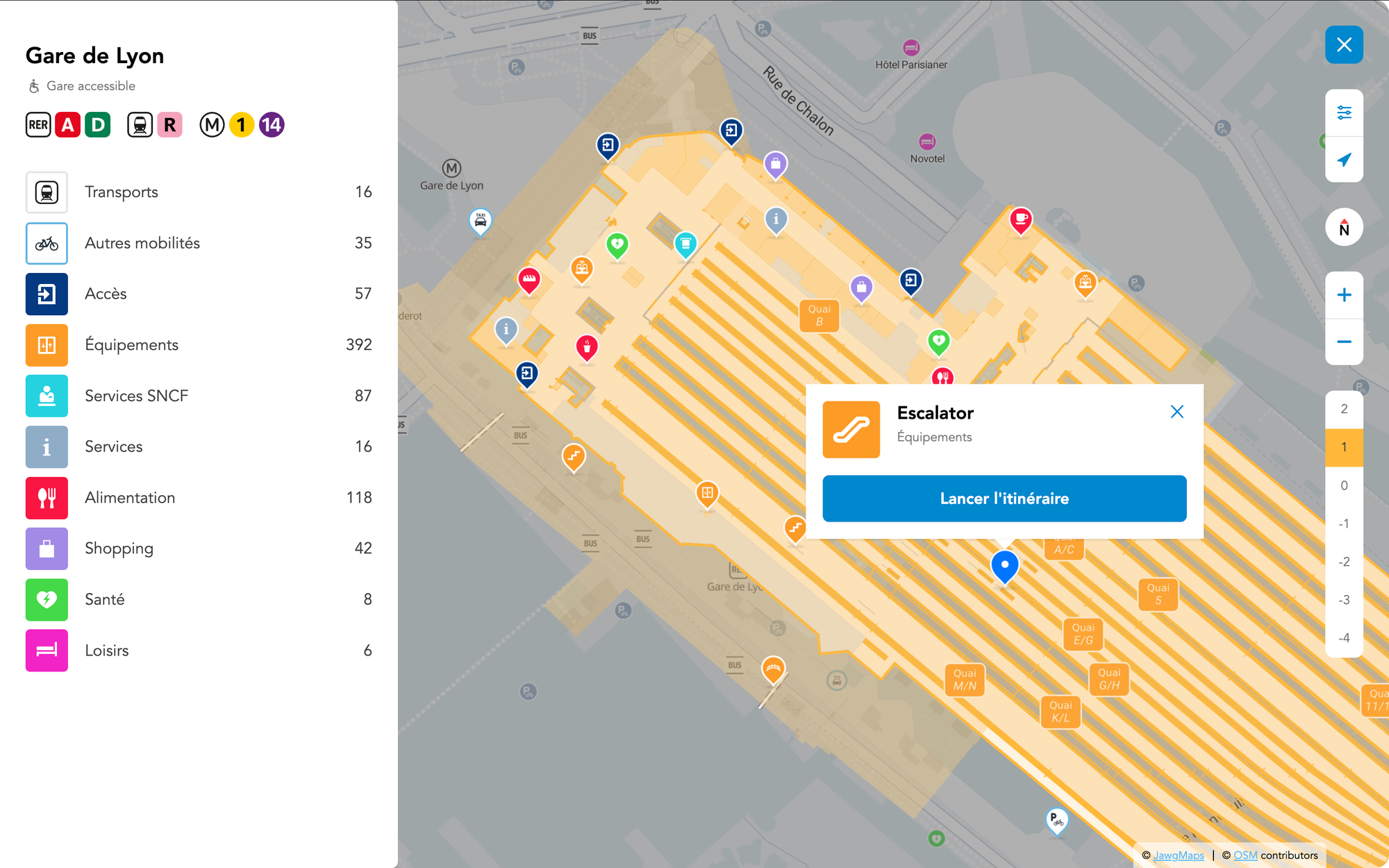
Above is a snapshot of how indoor mapping brings spaces to life with different elements like:
- Multi-level navigation: Clear indicators for escalators, elevators and staircases.
- Points of Interest (POIs): Essential locations like ticket machines, restrooms, shops and waiting areas.
- Pathways & routing: Step-by-step navigation, guiding travelers to platforms, ticketing areas, restrooms or specific shops within the station.
- Accessibility features: Optimized routes for people with reduced mobility, including elevator and ramp locations.
- Multimodal integration: Connection points between train services, metro lines, buses and shared mobility services.
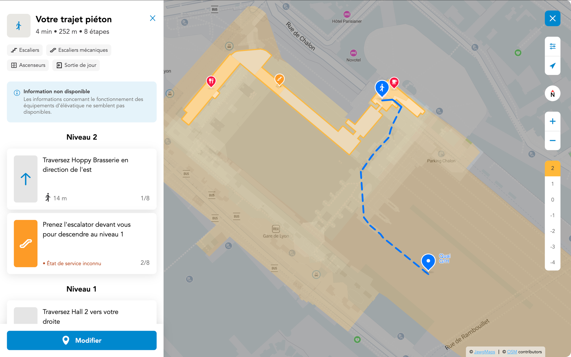
Routing example within Gare du Nord
This example provides clear step-by-step directions, including a stair-free option for accessibility:
Example of how you can navigate and get an itinerary in Gare du Nord, on several levels.
For SNCF and Transilien, indoor mapping plays a crucial role in improving passenger experience, particularly in busy stations where travelers need to quickly find their way to platforms, exits, ticket machines or amenities.
Technical deep dive: how indoor mapping works
Data collection & map creation
Indoor mapping starts with detailed spatial data collection using things like LiDAR scans, photogrammetry or manually annotated floor plans. This data is then transformed into structured digital maps compatible with mapping platforms like Jawg Maps 🗺️
In the case of SNCF, they developed a Visual Positioning System (VPS) as part of the Cartographie Digitale project, launched in 2019 to address GPS limitations in underground stations. The initiative involved capturing 500,000 images, mapping key locations, and integrating the data into OpenStreetMap.
To understand the entire process of how the stations were mapped, you can check out this presentation by Florian Lainez:
Rendering & user experience
Indoor maps are visualized using vector-based tiles and rendered dynamically based on user interactions. With Jawg Maps, developers can integrate multi-layered mapping solutions tailored to indoor environments, ensuring smooth rendering and efficient data loading.
More Cartographie Digitale project numbers
In October 2024, Transilien announced that is had deployed this indoor navigation system across more than 400 stations in Île-de-France! 🙌
Now available on transilien.com and the Andilien app since 2021, these interactive maps assist 3.6 million daily passengers, and it is particularly beneficial for those with reduced mobility, providing accessible routes with ramps and elevators.
Future updates are expected to include real-time information on escalator and elevator outages, with potential expansion to partner apps and AR devices. We can't wait to see this in action!
Beyond train stations
While SNCF and Transilien are using indoor mapping to improve station navigation, the technology has a broad range of applications across industries: airports, hospitals, shopping malls, corporate campuses or universities and the list goes on!
Are you ready to explore what’s possible with indoor mapping? Get in touch with Jawg Maps today or check out the Jawg GIS product page for more info.